In field sales, territory design is the foundation of efficiency. If your team's geographical boundaries are poorly structured, sales representatives waste time commuting rather than closing deals.
A dynamic approach to territory design ensures optimal resource management, balanced workloads, and maximum outlet coverage.

The Core Pillars of Dynamic Territory Design
Building a resilient field sales blueprint requires aligning structure, scheduling, and accountability. Below are the key pillars that support a data-driven territory design.
1. Multi-Level Geographical Hierarchy
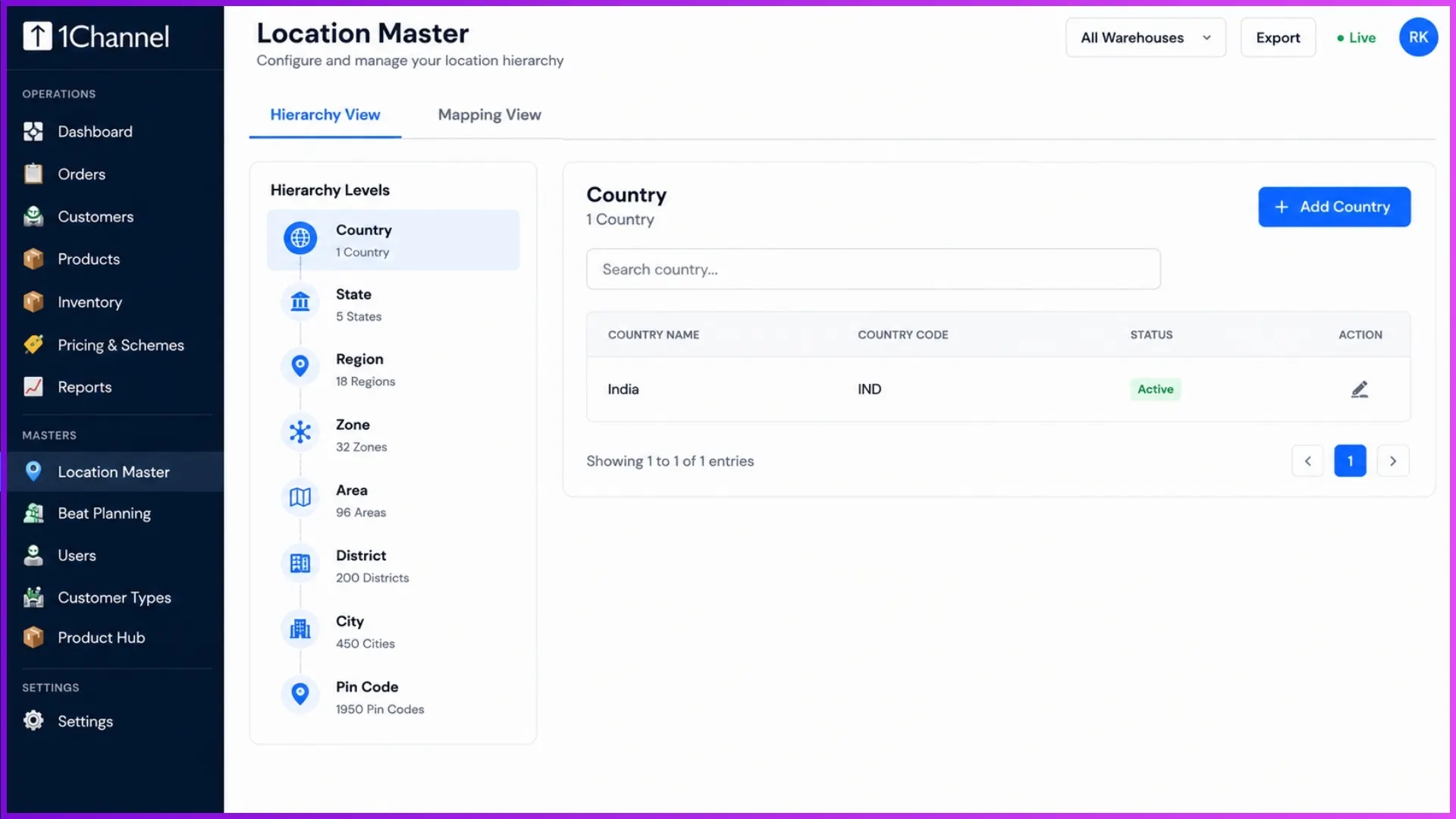
Every business follows a distinct geographic configuration depending on its scale. A dynamic territory system avoids hardcoded layouts and allows organizations to customize location depths flexibly.
- Configurable Levels: Easily establish setups like State → City → Pin Code or macro structures such as Zone → Region → District → Taluka.
- Centralized Alignment: This master geography links across the entire system, ensuring that data flows uniformly wherever physical locations are monitored.
2. Strategic Beat Planning
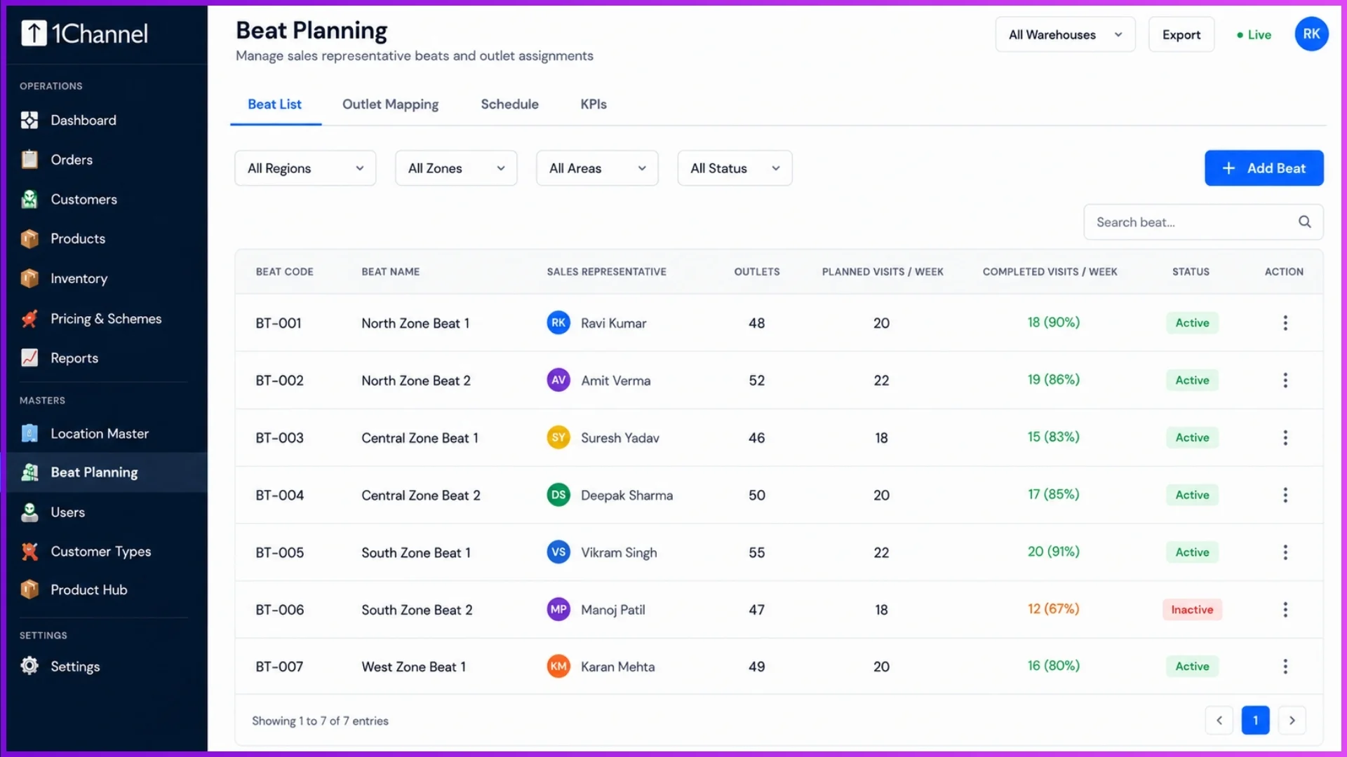
Once the geographical hierarchy is defined, areas are subdivided into beats (e.g., Udyog Vihar Phase 3, Udyog Vihar Phase 4). This allows field users to be precisely mapped to specific clusters of outlets.
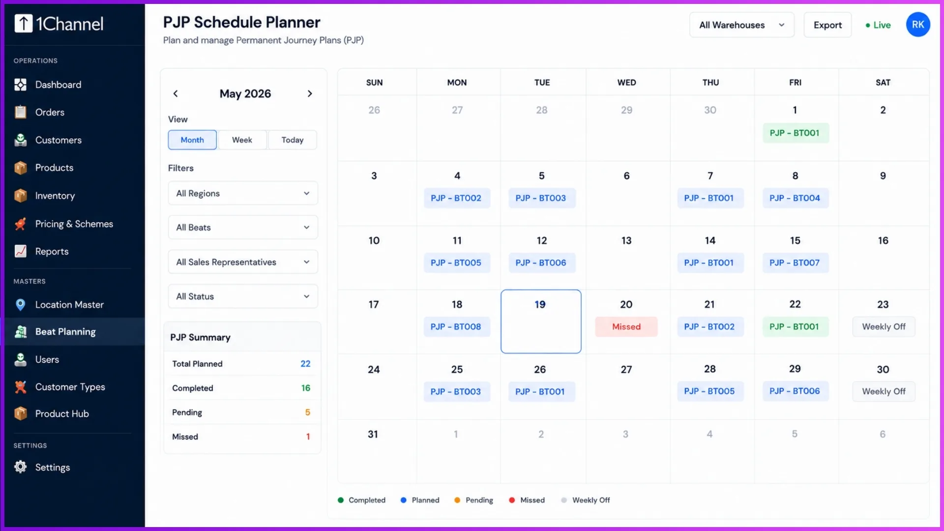
- Flexible Coverage: Managers can schedule visits by planning an entire beat (automatically including all outlets within it) or by handpicking specific high-priority outlets.
- Automated Routines: Similar to recurring calendar invites, you can create recurrence patterns for revisits, eliminating manual rescheduling.
3. Smart Geofencing & Verification
Territory design is only as good as its execution. Integrating proximity validation ensures sales representatives are physically present where they are needed.
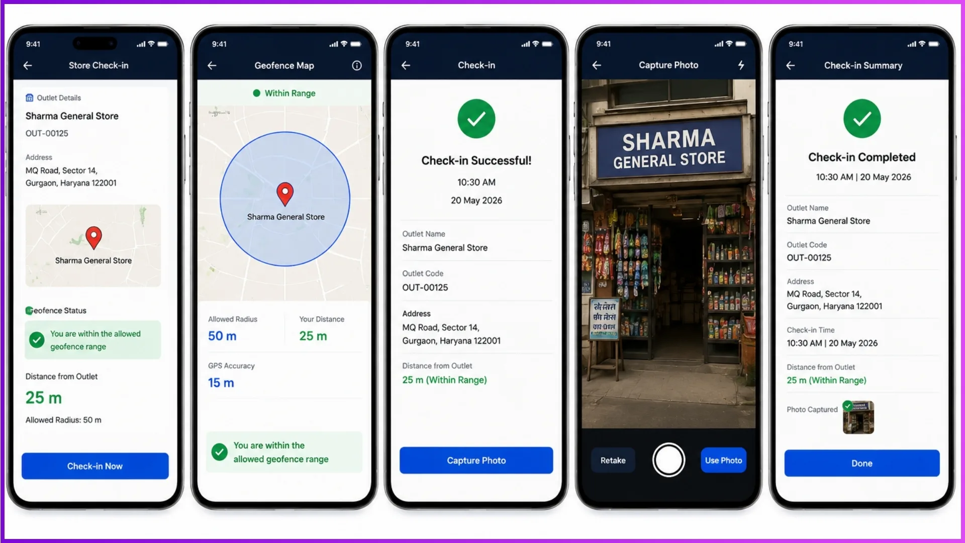
- Proximity Locks: Representatives must be within a configured radius (ranging from 50 to 5,000 meters, typically set to 300 meters) of the storefront to check in via their mobile app.
- Self-Mapping Locations: On the first visit to an unmapped retailer, the sales rep's GPS automatically registers and saves the correct outlet location alongside a mandatory storefront photo verification.
Visualizing Territory App Features
Below is a blueprint for implementing visual touchpoints across your mobile application to streamline field operations.
(Note: Software interfaces may vary depending on the client version.)
1. Location Master Configuration Dashboard
2. Sales Representative Beat Mapping Screen
3. Calendar-Based PJP Schedule Planner
4. Mobile App Store Check-in with Geofence Marker
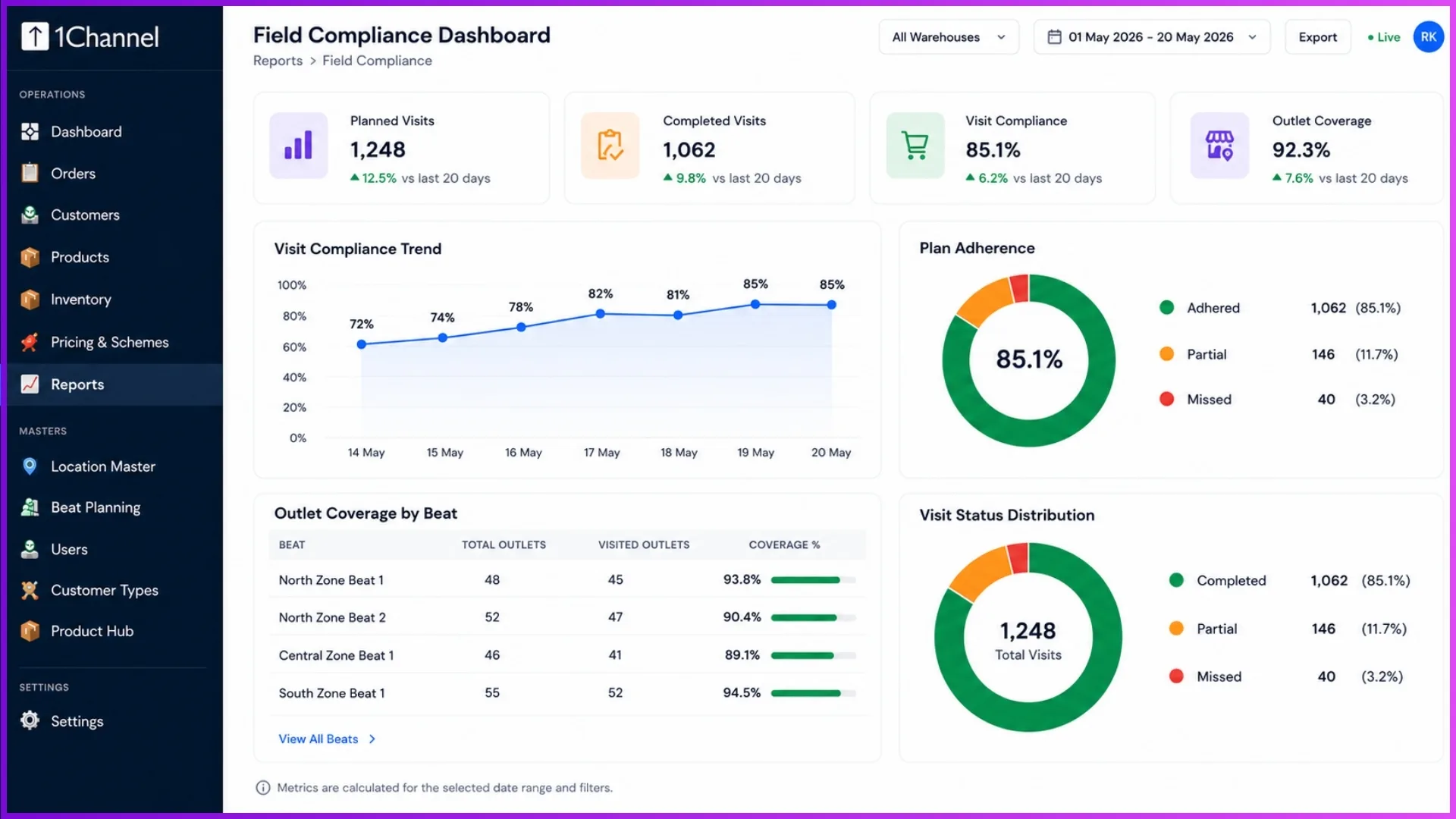
5. Field Compliance Analytics Dashboard
Driving Performance with Target Tracking
Dynamic territories go hand-in-hand with smart objectives. Organizations can track performance through two major lenses:
- Visit-Based Targets: Measuring compliance, plan adherence, and overall coverage of assigned outlets.
- Product-Based Targets: Setting volume or value-based sales quotas at the Brand, Category, Product, or SKU level.
Furthermore, you can define exactly when an achievement counts—whether immediately upon order placement or only after final dispatch/invoice generation. This ensures target transparency across your entire reporting hierarchy.
Revolutionize Operations with 1Channel
To seamlessly execute this blueprint, businesses need a comprehensive Field Force Automation and Distributor Management System (DMS).
Elevate Field Force Capabilities with 1Channel
1Channel provides organizations with a robust, highly configurable platform designed to handle complex geographical hierarchies, automated beat scheduling, and ironclad geofencing features.
With its built-in AI assistant, field managers can query real-time data, such as checking pending orders or compliance metrics, instantly via chat.
From managing roles and customer-specific price lists to tracking live target achievements, 1Channel removes the guesswork from field operations, driving visibility and productivity.
Explore 1Channel Territory & Beat Management Software
See how 1Channel's Territory & Beat Management Software configures multi-level geographical hierarchies, automates beat planning, and enforces geofencing to keep field teams accountable.
Explore Territory & Beat Management →Frequently Asked Questions (FAQs)
Q1: How does the system handle organizations with complex regional variations?
The Geography Master is completely modular. During project setup, you can configure custom hierarchy levels matching your exact market layout, allowing user mappings and price lists to adjust according to specific geographies.
Q2: What happens if a sales representative is unable to check in due to incorrect location data?
On the very first visit to an outlet without saved coordinates, the system captures the representative's real-time GPS location and saves it as the verified outlet location, supported by a mandatory storefront photo.
Q3: Can beats be automated for recurring visits?
Yes. The scheduling wizard includes a "Recurrence" feature that allows managers to establish automated revisit schedules for specific outlets, functioning seamlessly like a recurring calendar meeting.
Note: Software screens may vary based on your business structure and configured workflows.